4

I've been having some difficulty keeping a reliable connection at my house, so I installed the OpenSignal app to see what might be going on. According to its map, I live in a "hole" between several different towers.

However, the pointer on its home screen doesn't seem to make any sense. It's supposed to tell me where the tower is that I'm connected to, but it seems to rotate faster than necessary to account for me rotating the phone (unlike a compass needle), and it seems to be fascinated with my home stereo speakers when I bring it close to them. (like a compass needle pointing to the speakers' magnet)

So is this a legitimate radio problem? Or is somebody's software getting confused?


I've gotten a lot of feedback about OpenSignal being worthless, but it was only meant to be a diagnostic tool for the problem of getting a more reliable connection. The reason to know where the towers are, and specifically the one I'm connected to, is to somewhat intelligently play with placement. (I'm mostly using the data connection for a WiFi hotspot, so an awkward location isn't all that bad.) If there's a better app or methodology, I'm all ears.

2
  • 1
    The biggest problem I've seen with OpenSignal's mapping is it's all from user gathered statistics and FCC registered locations, so many things like Network Extenders for example, report as "towers", and it often tells me areas like downtown St Paul or Minneapolis that there are 20, 30, even 40+ towers near me... I have literally driven to a few of these "tower" locations and it's usually just a house or business. Don't trust tower locations in the app.
    – acejavelin
    Commented Jul 13, 2017 at 19:42
  • Locations of tower are from very old data so the app will not help. Moreover, I don't think you can get location of connected towers by any mean. Commented Jul 13, 2017 at 23:18

2 Answers 2

3

From app blogs Methodology explains how they collect data

  • Crowd Sourcing (already pointed in comments)

  • Monitoring users who installed app continuously

So, the accuracy pretty much depends on how many people use the app with GPS on

  • Data Analytics

Also see Cell towers/wifi routers not located correctly which is dated but relevant

This app was recently launched in India and I noticed this

  1. Cell towers are very well mapped of a provider, though, in my area tower density is low ( likely because provider made it open source as a part of publicity )

  2. Cell towers are not well mapped, for another provider, though the tower density is much higher

Not a very dependable app , IMO

0

The solution to your issue would be to "fill in" the data. Crowdsourced maps require lots of data points to build a representation of the real world and you sitting in your house is really a single data point (possibly two if you alternate between cells).

Personally I recommend "CellMapper" over OpenSignal but either should work.

Methodology:

  1. Open Recording App
  2. Wait for good GPS lock
  3. Move around the area where your cell (or sector thereof) is located/focused

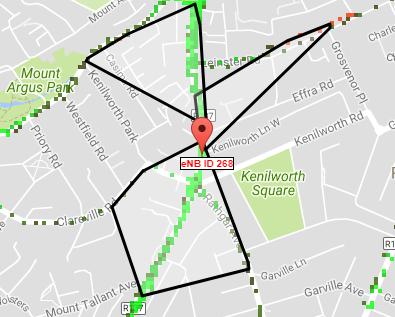
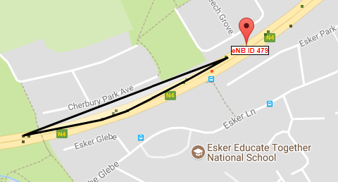
Most high sites have 3x sectors (think pizza slices) so by recording points in each you triangulate the point in the middle where the site is or should be. More data, more accuracy. Below is an example of poor data (probably wrong) and an example of good data (probably close).

Poor Data

Good Data

Note: Once the preliminary collection is done you can manually locate the cell (they can often be seen from the street) and then fine tune the sites position.

You must log in to answer this question.

Not the answer you're looking for? Browse other questions tagged .